


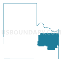
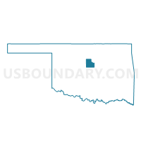
Voting District 203, Logan County, Oklahoma
About
Outline

Summary
| Unique Area Identifier | 654315 |
| Name | Voting District 203 |
| County | Logan County |
| State | Oklahoma |
| Area (square miles) | 84.22 |
| Land Area (square miles) | 83.52 |
| Water Area (square miles) | 0.70 |
| % of Land Area | 99.17 |
| % of Water Area | 0.83 |
| Latitude of the Internal Point | 35.87690990 |
| Longtitude of the Internal Point | -97.21877840 |
Maps

Graphs
Select a template below for downloading or customizing gragh for Voting District 203, Logan County, Oklahoma


Neighbors
Neighoring Voting District (by Name) Neighboring Voting District on the Map
- Voting District 201, Logan County, OK
- Voting District 204, Logan County, OK
- Voting District 207, Logan County, OK
- Voting District 305, Logan County, OK
- Voting District 309, Logan County, OK
- Voting District 6, Lincoln County, OK
- Voting District 7, Lincoln County, OK
Top 10 Neighboring County Subdivision (by Population) Neighboring County Subdivision on the Map
- Guthrie CCD, Logan County, OK (32,848)
- East Logan CCD, Logan County, OK (4,338)
- Northwest Lincoln CCD, Lincoln County, OK (4,140)
Top 10 Neighboring Place (by Population) Neighboring Place on the Map
Top 10 Neighboring Unified School District (by Population) Neighboring Unified School District on the Map
- Guthrie Public Schools, OK (22,755)
- Perkins-Tryon Public Schools, OK (7,744)
- Luther Public Schools, OK (5,276)
- Coyle Public Schools, OK (4,013)
Top 10 Neighboring State Legislative District Lower Chamber (by Population) Neighboring State Legislative District Lower Chamber on the Map
- State House District 31, OK (44,222)
- State House District 33, OK (37,766)
- State House District 32, OK (36,057)
Top 10 Neighboring State Legislative District Upper Chamber (by Population) Neighboring State Legislative District Upper Chamber on the Map
- State Senate District 41, OK (88,446)
- State Senate District 21, OK (81,344)
- State Senate District 19, OK (77,948)
Top 10 Neighboring 111th Congressional District (by Population) Neighboring 111th Congressional District on the Map
Top 10 Neighboring Census Tract (by Population) Neighboring Census Tract on the Map
- Census Tract 6005, Logan County, OK (7,281)
- Census Tract 6006, Logan County, OK (4,338)
- Census Tract 9612, Lincoln County, OK (4,140)
Top 10 Neighboring 5-Digit ZIP Code Tabulation Area (by Population) Neighboring 5-Digit ZIP Code Tabulation Area on the Map
- 73044, OK (20,226)
- 74059, OK (5,476)
- 74881, OK (4,509)
- 73027, OK (1,493)
- 73050, OK (1,370)
- 73058, OK (332)